Homewood's 11 main areas, from Rosedale to Forest Brook: ZIP codes, elementary zones and September 2026 Zillow home values for each, with a map.
Last checked Oct. 17, 2026. Sources: the City of Homewood’s history page, the Homewood Historic Preservation Commission’s neighborhoods tour, the city’s comprehensive plan update, the city’s address and school zone map layers, the state’s report card, Zillow Research, the Census Bureau and OpenStreetMap.
Homewood is a city of 27,829 people in Jefferson County, according to the Census Bureau’s 2020-2024 American Community Survey five-year estimates. It sits in Shades Valley, on the south side of Red Mountain from downtown Birmingham. The Red Mountain Expressway, U.S. 31 and U.S. 280, comes over the mountain at the city’s north end; U.S. 31 runs south through the middle of town; U.S. 280 runs along the east side; and Interstate 65 runs along the west side, with exits 254, 255 and 256 in or beside the city and exit 258 just north. City Hall is downtown at 2850 19th St. S.
Three of today’s neighborhoods, Rosedale, Edgewood and Grove Park, voted in September 1926 to incorporate as Homewood. The city of Hollywood was annexed in 1929 and Oak Grove, in West Homewood, in 1955, the city’s history page says.
Three things to know before you look at a listing:
- ZIP codes do not follow city limits. In the city’s address map, 90% of Homewood’s 9,502 address points use 35209. The rest use 35226, which Zillow files under Hoover, 35216, which it files under Vestavia Hills, and small groups in 35210 and 35223. Homes with those ZIP codes may be in another city; check the city on the parcel with Jefferson County.
- One school system, three elementary zones. Every Homewood address goes to Homewood City Schools, Homewood Middle and Homewood High. The elementary zone depends on the address, and five of the 11 areas below are split. Use the district’s school locator map, which the district says is not legally binding, and call residency and enrollment at 205-870-2011.
- City services stop at the city line. Homewood police, Homewood Fire Department and the city’s Amwaste trash contract cover addresses inside the limits; a Birmingham, Mountain Brook or Vestavia Hills address across the street is served by that city.
The areas at a glance
Every Homewood address is zoned for Homewood High, which earned an A (94) on the state’s 2024-25 report card. The elementary column shows the zones of each area’s address points in the city’s school zone layer on Oct. 17. Home values are the Zillow Home Value Index for September 2026: a modeled typical value for the middle third of homes in the whole ZIP code, not a sale price. The citywide Homewood figure was $568,543, up 6.59% on the year.
| Area | ZIP | Elementary zone (share of address points) | Typical value in its ZIP | Page |
|---|---|---|---|---|
| Downtown | 35209 | Shades Cahaba | $536,460 | Downtown |
| Rosedale | 35209 | Shades Cahaba | $536,460 | Rosedale |
| Grove Park | 35209 | Edgewood 57%, Shades Cahaba 43% | $536,460 | Grove Park |
| Edgewood | 35209 | Edgewood 62%, Hall-Kent 38% | $536,460 | Edgewood |
| Mayfair and Windsor Highlands | 35209 | Edgewood 53%, Shades Cahaba 47% | $536,460 | Mayfair and Windsor Highlands |
| Hollywood | 35209 | Shades Cahaba | $536,460 | Hollywood |
| Brookwood Village | 35209 | Shades Cahaba | $536,460 | Brookwood Village |
| Lakeshore | 35209, 35216 | Edgewood 40%, Shades Cahaba 38%, Hall-Kent 22% | $536,460; $409,889 | Lakeshore |
| West Homewood | 35209 | Hall-Kent 91%, Edgewood 9% | $536,460 | West Homewood |
| Wildwood | 35209, 35216 | Hall-Kent | $536,460; $409,889 | Wildwood |
| Forest Brook and Huntington Park | 35226 | Hall-Kent | $436,667 | Forest Brook and Huntington Park |
The three elementary schools all earned A grades on the 2024-25 state report card: Edgewood Elementary (100), Shades Cahaba Elementary (99) and Hall-Kent Elementary (96). Homewood Middle earned an A (97). More in our schools guide and home prices guide.
Map
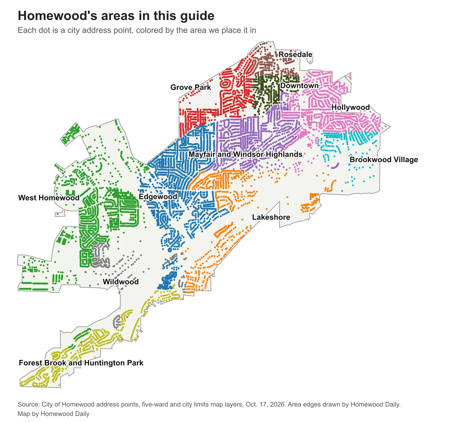
Map: Homewood Daily, from the City of Homewood’s address points, five-ward map and city limits layers, checked Oct. 17, 2026. The area edges are ours.
The areas
Downtown. The town center along 18th Street South and 28th and 29th avenues South, with City Hall. The draft comprehensive plan map lists it among the “Areas to Strengthen.” Street parking is limited to three hours.
Rosedale. A founding village at the north end, under Red Mountain, with the Rosedale Historic District, Spring Park and the Lee Community Center. Ward 1 of the Historic Preservation Commission’s tour.
Grove Park. The third founding village, between downtown and Edgewood, with Central Park, the Homewood Community Center, Homewood Middle and Sims Garden.
Edgewood. The village that grew most before 1926, around Oxmoor Road and Broadway Street, with its own business district and the Dawson parking deck. Ward 3 of the tour.
Mayfair and Windsor Highlands. Residential streets between downtown and Samford, with Overton Park and the Homewood Public Library. Part of the tour’s Ward 4.
Hollywood. A separate town until 1929, on the east side along Hollywood Boulevard, with the Hollywood Historic District. Ward 5 of the tour. Sidewalk work on the Hollywood Boulevard bridge over U.S. 280 began Aug. 3.
Brookwood Village. The mall district at U.S. 280 and Lakeshore Drive, shared with Mountain Brook, with Brookwood Medical Center and Target. Homewood and Mountain Brook agreed in 2024 to plan the mall’s redevelopment together.
Lakeshore. The south side along Lakeshore Drive: Samford University, Homewood High, the soccer park and the Shades Creek Greenway. Part of the tour’s Ward 4.
West Homewood. The west side around Oxmoor Road, with Patriot Park, the athletic complex and Hall-Kent Elementary. Ward 2 of the tour.
Wildwood. The big-box shopping district on Lakeshore Parkway at I-65 exit 255, with homes and apartments around it. The draft plan lists it among the “Areas to Transform.”
Forest Brook and Huntington Park. The residential streets on the south edge, the only part of Homewood in ZIP 35226.
Comparing Homewood with the cities next door? See Homewood vs. Vestavia Hills vs. Birmingham vs. Mountain Brook. New to town? Our moving to Homewood guide lists the offices to call, and our property tax guide explains the bill.
How we built this
The area names come from the city’s own sources: the history page (Rosedale, Edgewood, Grove Park, Hollywood and Oak Grove), the Historic Preservation Commission’s driving tour of the five historic wards (Rosedale, West Homewood, Edgewood, Lakeshore, Mayfair and Windsor, and Hollywood), and the draft growth and conservation map in the July 22, 2026, comprehensive plan workshop (PDF), which also names Windsor Highlands, Huntington Park, Forest Brook, downtown, Wildwood and Brookwood Village. OpenStreetMap’s place names (© OpenStreetMap contributors) confirm Edgewood, Hollywood, Mayfair, Rosedale, Grove Park, Windsor Highlands and Huntington Park. We left out names we could not place on a map from a source, such as Drexel Hills.
The edges are ours. We started from the city’s five-ward map layer, whose ward numbers match the starting points of the tour’s five historic wards, split Ward 1 into Rosedale, downtown and Grove Park, Ward 4 into Mayfair and Windsor Highlands and Lakeshore, and Ward 5 into Hollywood and Brookwood Village, drew Wildwood around the Lakeshore Parkway stores, and gave every ZIP 35226 address to Forest Brook and Huntington Park. School shares count every city address point inside each area against the city’s school zone layer, checked Oct. 17, 2026. Road distances on the area pages are measured on the OpenStreetMap network with the OSRM routing engine.
Frequently asked questions
What are the neighborhoods in Homewood, Alabama?
Our guide covers 11 areas: Downtown, Rosedale, Grove Park, Edgewood, Mayfair and Windsor Highlands, Hollywood, Brookwood Village, Lakeshore, West Homewood, Wildwood, and Forest Brook and Huntington Park. The names come from the city’s history page, the Historic Preservation Commission’s tour of Homewood’s five historic wards, the draft comprehensive plan map and OpenStreetMap.
What ZIP codes are in Homewood?
Most Homewood addresses, 90% of the city’s address points, use 35209. Smaller groups use 35226 (the Forest Brook and Huntington Park streets), 35216 (parts of Lakeshore and Wildwood), 35210 and 35223. Samford University has its own ZIP code, 35229.
Is all of Homewood in Homewood City Schools?
Yes. Every address inside the city limits is served by Homewood City Schools: one of three elementary schools, then Homewood Middle and Homewood High. A ZIP code alone does not tell you the city, so check the parcel.
Do Homewood elementary school zones follow neighborhood lines?
No. Edgewood, Grove Park, Mayfair and Windsor Highlands, Lakeshore and West Homewood are each split between two or three elementary zones in the city’s school zone map. Check one address with the district’s school locator.
Have your say